Culture® 4.0
The Contextual Guide and Internet Index
to Western Civilization

-- Culture 4.0 Historical
Maps --
Historical Maps Overview
(This page is from the Culture
4.0 program -- all of the WWW links to maps on the
internet are functional but only 21 of the 159 internal maps are active
on this website.)
Intro -- Sources
Maps Grouped by Period
Biblical -- Greece --
Rome
Medieval
(Post-Roman -- Celtic
-- Carolingian -- Romanesque
-- Early Gothic -- Late Gothic)
Renaissance -- Baroque --
Classic -- Romantic -- 20th Century
Maps Grouped Geographically
The Americas -- Asia --
Baltic Lands -- England/Britain
-- Europe -- France
Germany/Austria -- Italy --
Middle East -- Spain
Introduction
This document lists all historical maps either (1) directly accessed
from the Culture 4.0 CD-ROM (159 internal images stored as JPG files), or
(2) or externally accessed at WWW (internet)
sites linked by the program. These maps, the bulk of them being scans from
early 20th-Century historical atlases, are listed below, both chronologically
by era and geographically. While these sources are now public domain, the
image scans utilized in Culture 4.0 are copyrighted by CRI. These may be
freely used for educational or personal purposes but not for any commercial
undertaking without the express written permission of CRI.
Sources for Culture 4.0 Historical Maps (internal
images)
- The Century Atlas of the World, prepared under the Superintendence
of Benjamin E. Smith, A.M., Managing Editor of the Century Dictionary,
Editor of the Century Cyclopedia of Names, Fellow of the American Geographic
Society, Etc. Published by The Century Co., New York, 1900.
- Atlas to the Historical Geography of Europe, by Edward A. Freeman,
D.C.L., LL.D., formerly Regius Professor of Modern History in the University
of Oxford. Third Edition. Edited by J.B. Bury, M.A., D.Litt., LL,D., Regius
Professor of Modern History in the University of Cambridge. Longmans, Green,
and Co., 39 Paternoster Row, London, New York and Bombay, 1903.
- Philips' New Historical Atlas for Students, by Ramsay Muir,
M.S., Professor of Modern History in the University of Manchester, George
Philip & Son, Ltd., London: The Londond Geographical Institute, 32
Fleet St., E.C., 1911.
- WWW -- General Resources for Historical
Maps
- Link Lists
- Historical Map Archives
Biblical History and Antiquity
- Internal Maps -- Biblical History and Antiquity
- The Chaldean, Elamitic and Hittite Powers -- Available on Culture
4.0 CD-ROM.
- The Egyptian, Assyrian, Babylonian and Median Powers -- Available
on Culture 4.0 CD-ROM.
- Probable Route of the Exodus -- Available on Culture 4.0 CD-ROM.
- Canaan as Divided Between the Twelve Tribes -- Available on Culture
4.0 CD-ROM.
- Israel, c.1000 B.C. -- Available on Culture 4.0 CD-ROM.
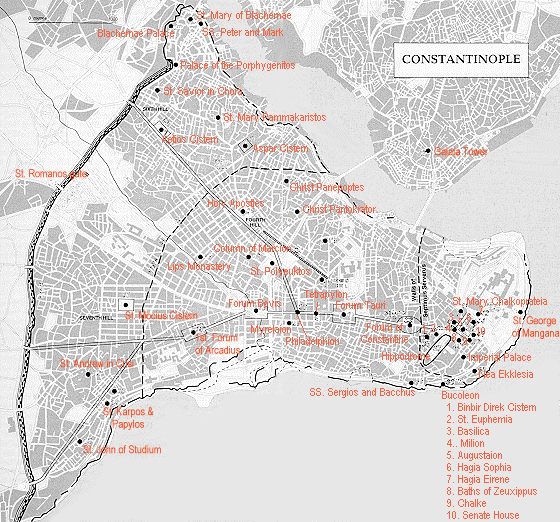
- Ancient Jerusalem
- Palestine at the Time of Christ
- WWW Maps -- Biblical History and Antiquity
Greece (1260-264 B.C.)
- Internal Maps -- Greece (1260-264 B.C.)
- Homeric Greece and Neighboring Lands -- Available on Culture 4.0
CD-ROM.
- Greece and the Greek Colonies -- Available on Culture 4.0 CD-ROM.
- Greece in the 5th Century B.C.
- Ancient Athens
- Ancient Greece and Asia Minor -- Available on Culture 4.0 CD-ROM.
- The Persian Empire (c.500 B.C.) and the Empire of Alexander the Great
(323 B.C.) -- Available on Culture 4.0 CD-ROM.
- Dominions of Alexander c.323 B.C. -- Available on Culture 4.0 CD-ROM.
- Successors of Alexander c.300 B.C. -- Available on Culture 4.0 CD-ROM.
- Aegean Lands c.227 B.C. -- Available on Culture 4.0 CD-ROM.
- WWW Maps -- Greece (1260-264 B.C.)
Rome (753 B.C.-400 A.D.)
- Internal Maps -- Rome (753 B.C.-400 A.D.)
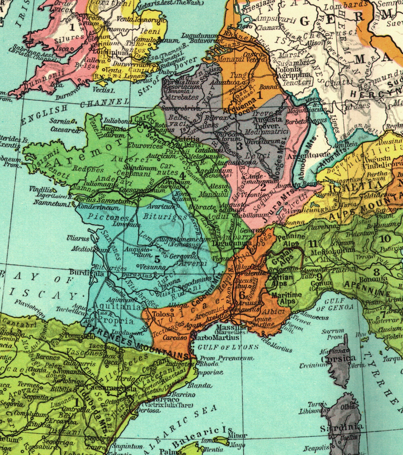
- Pre-Roman Italy -- Available on Culture 4.0 CD-ROM.
- Ancient Italy -- Available on Culture 4.0 CD-ROM.
- Aegean Lands c.227 B.C. -- Available on Culture 4.0 CD-ROM.
- Mediterranean Lands at the beginning of the Second Punic War -- Available
on Culture 4.0 CD-ROM.
- Ancient Rome -- Available on Culture 4.0 CD-ROM.
- Roman Dominions, 64 B.C. -- Available on Culture 4.0 CD-ROM.
- The Roman Empire at the Death of Augustus, 13 A.D. -- Available
on Culture 4.0 CD-ROM.
- Roman Empire, c.117 A.D.
- The Roman Empire Divided into Prefectures -- Available on Culture
4.0 CD-ROM.
- Britannia, c.350 -- Available on Culture 4.0 CD-ROM.
- Roman Britain, c.350
- WWW Maps -- Rome (753 B.C.-400 A.D.)
Middle Ages (400-1400)
- WWW Maps -- General Medieval (400-1400)
- Maps and Images
(Medieval Sourcebook) -- An excellent medieval archive chiefly stocked
with several early 20th-century historical atlases; select links to other
sites. Another nice job by Paul Halsall.
- Medieval
Maps (Matthew White) -- Links.
- Alison Stones' medieval pages at U. of Pittsburgh (William Shepherd's
Historical Atlas, 1929)
- Post-Roman and Pre-Gregorian (400-600)
- Internal Maps
- Britannia, c.350 -- Available on Culture 4.0 CD-ROM.
- Roman Britain, c.350
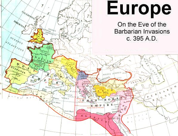
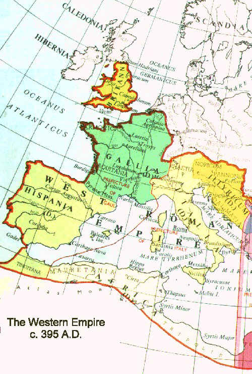
- Europe c.476 A.D. -- Available on Culture 4.0 CD-ROM.
- Europe in the Reign of Theodoric, c.500 A.D. -- Available on Culture
4.0 CD-ROM.
- Europe c.520 A.D. -- Available on Culture 4.0 CD-ROM.
- Europe at the Death of Justinian, 565 A.D. -- Available on Culture
4.0 CD-ROM.
- English Conquest from 450 to the End of the Sixth Century -- Available
on Culture 4.0 CD-ROM.
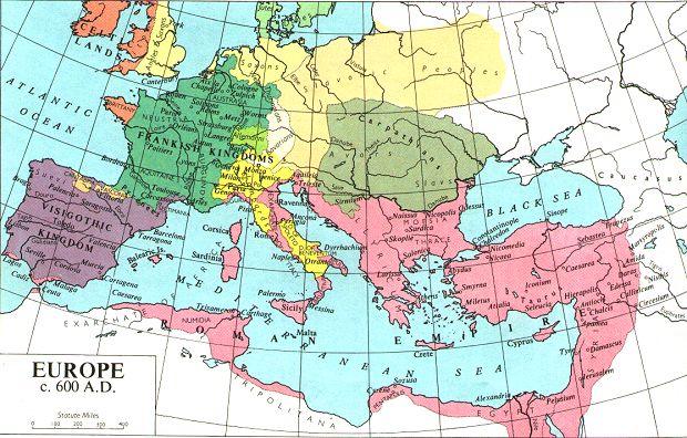
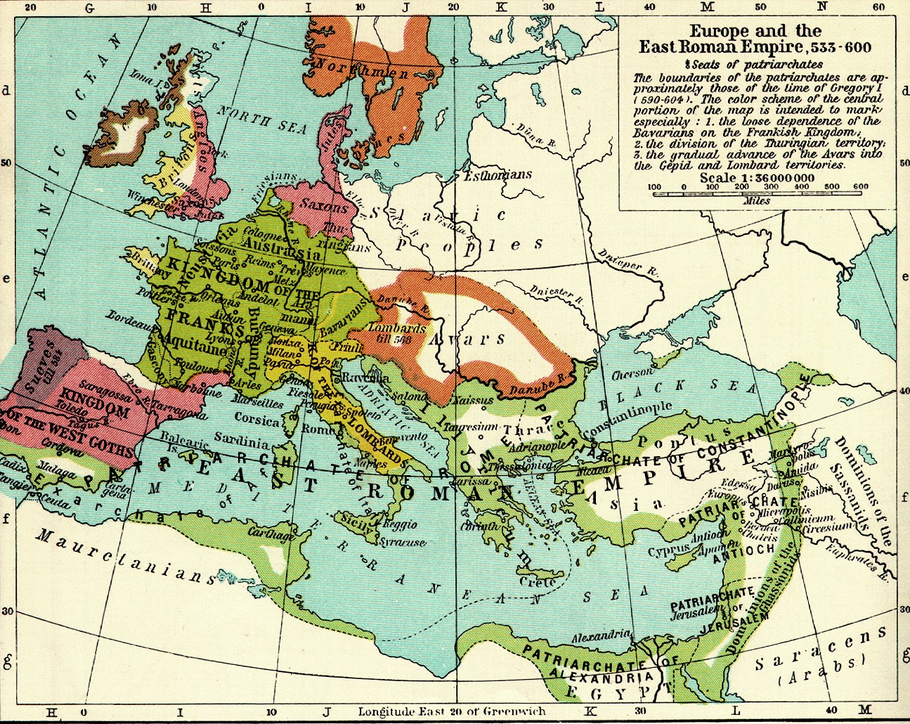
- Europe c.600 A.D. -- Available on Culture 4.0 CD-ROM.
- Italy, c.600 -- Available on Culture 4.0 CD-ROM.
- The English Conquest of Britain, 550-800 -- Available on Culture
4.0 CD-ROM.
- British Isles and their Teutonic Invadors (4th-9th Centuries) -- Available
on Culture 4.0 CD-ROM.
- WWW Maps -- Post-Roman and Pre-Gregorian
(400-600)
- Celtic & Gregorian (600-800)
- Internal Maps
- Italy, c.600 -- Available on Culture 4.0 CD-ROM.
- Europe c.600 -- Available on Culture 4.0 CD-ROM.
- Europe c.650
- Europe, 695 -- Available on Culture 4.0 CD-ROM.
- England in the 8th Century (The Heptarchy) -- Available on Culture
4.0 CD-ROM.
- England in the 8th Century -- Available on Culture 4.0 CD-ROM.
- Europe c.800 -- Available on Culture 4.0 CD-ROM.
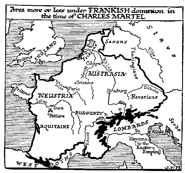
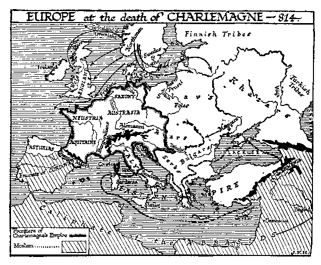
- The Empire of Charlemagne
- The English Conquest of Britain, 550-800 -- Available on Culture
4.0 CD-ROM.
- British Isles and their Teutonic Invadors (4th-9th Centuries) -- Available
on Culture 4.0 CD-ROM.
- WWW Maps -- Celtic & Gregorian
(600-800)
Carolingian & Ottonian (800-1000)
- Internal Maps
- Europe c.800 -- Available on Culture 4.0 CD-ROM.
- The Empire of Charlemagne
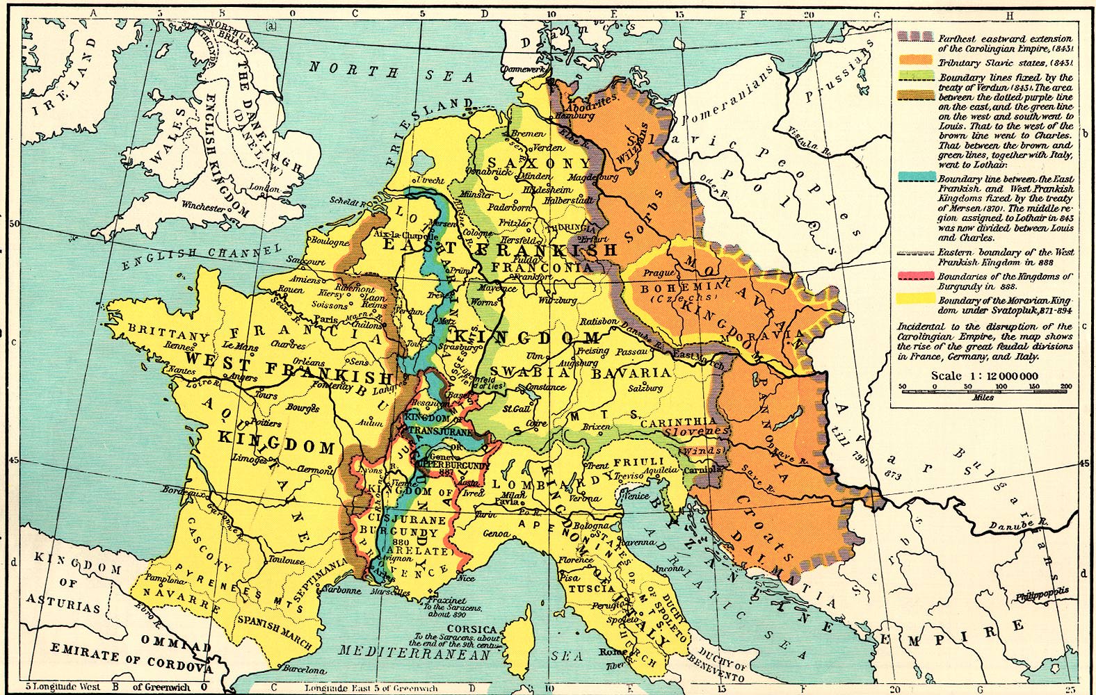
- Central Europe, 843 -- Available on Culture 4.0 CD-ROM.
- Central Europe, 870 -- Available on Culture 4.0 CD-ROM.
- England at the Treaty of Wedmore, 878 -- Available on Culture 4.0
CD-ROM.
- Central Europe, 887 -- Available on Culture 4.0 CD-ROM.
- British Isles and their Teutonic Invadors (4th-9th Centuries) -- Available
on Culture 4.0 CD-ROM.
- South Eastern Europe, 910 -- Available on Culture 4.0 CD-ROM.
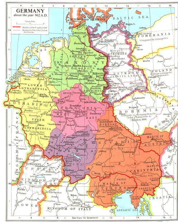
- Germany, c.962 -- Available on Culture 4.0 CD-ROM.
- Central Europe, 980 -- Available on Culture 4.0 CD-ROM.
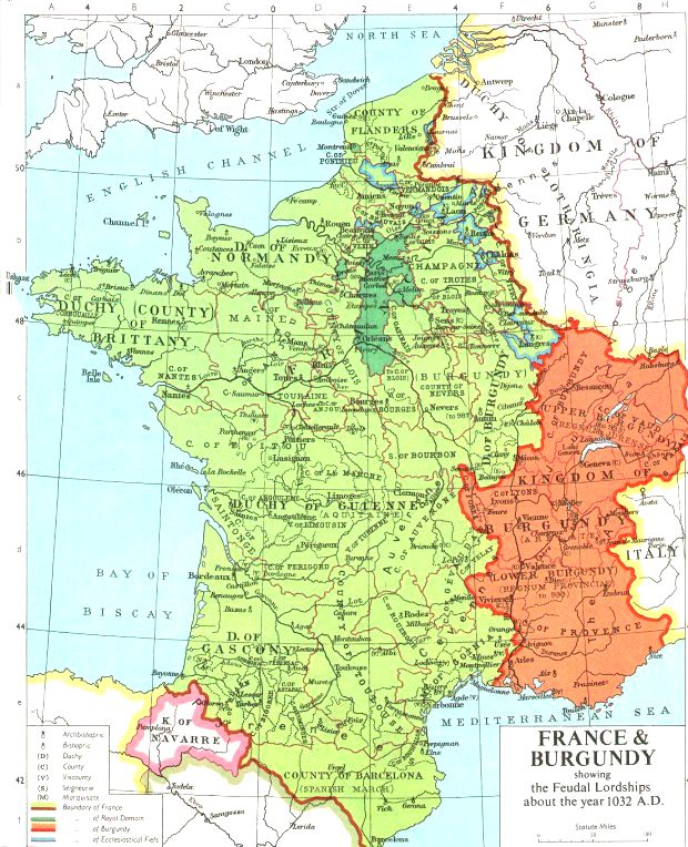
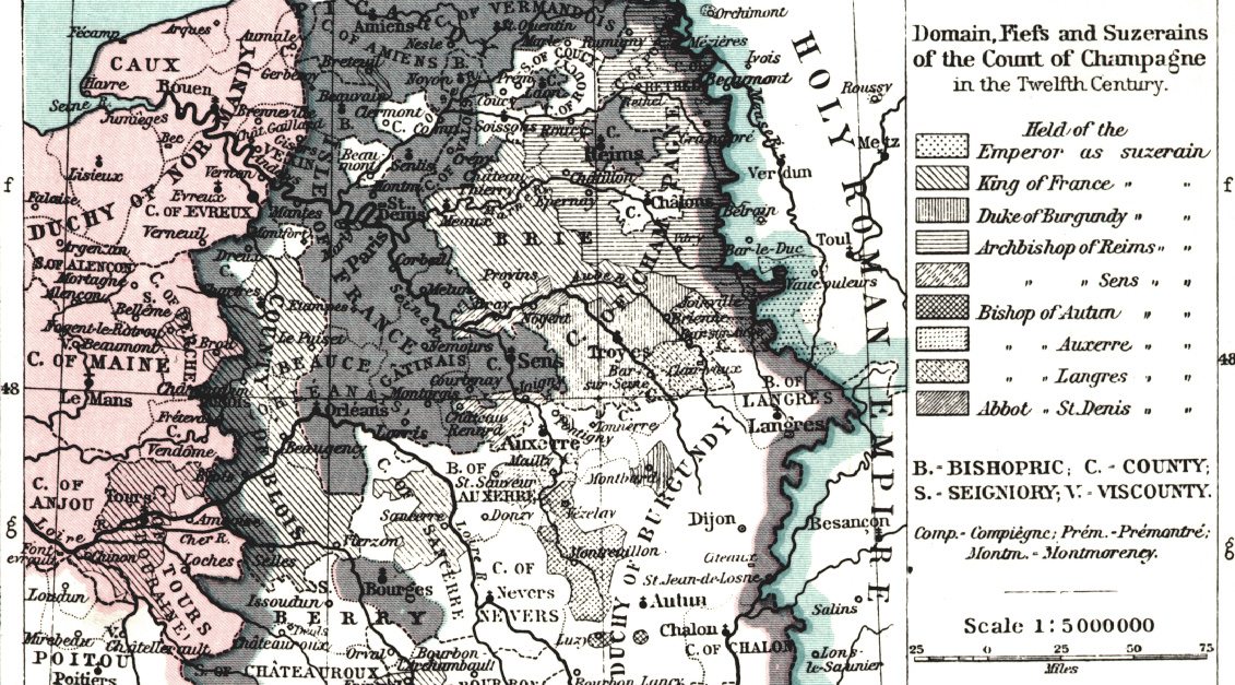
- France and Burgundy, 987 -- Available on Culture 4.0 CD-ROM.
- South Eastern Europe, 1000 -- Available on Culture 4.0 CD-ROM.
- Baltic Lands, 1000 -- Available on Culture 4.0 CD-ROM.
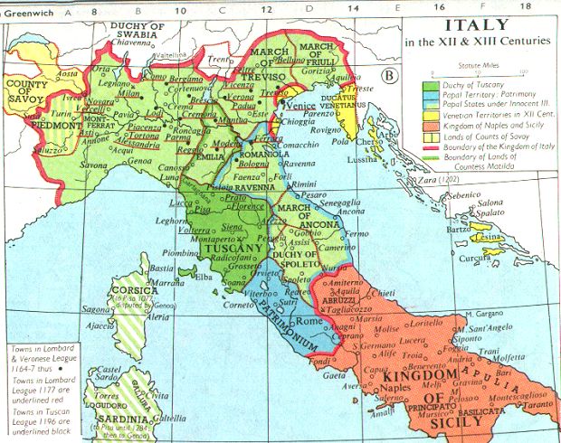
- Italy in the X, XII, XIII and XV Centuries
- Greatest Extent of the Saracen (Muslim) Dominions -- Available on
Culture 4.0 CD-ROM.
- WWW Maps -- Carolingian & Ottonian
(800-1000)
Romanesque & Norman (1000-1150)
- Internal Maps
- Greatest Extent of the Saracen (Muslim) Dominions -- Available on
Culture 4.0 CD-ROM.
- Baltic Lands, 1000 -- Available on Culture 4.0 CD-ROM.
- South Eastern Europe, 1000 -- Available on Culture 4.0 CD-ROM.
- Spanish Kingdoms, 1030 -- Available on Culture 4.0 CD-ROM.
- South Eastern Europe, 1040-1070 -- Available on Culture 4.0 CD-ROM.
- England and Her Invaders in the 11th Century -- Available on Culture
4.0 CD-ROM.
- England on the Eve of the Norman Conquest, c.1060 -- Available on
Culture 4.0 CD-ROM.
- Italy in the X, XII, XIII and XV Centuries
- Europe at the Time of the First Crusade, c.1100
- The Iberian Peninsula at the Beginning of the 12th Century -- Available
on Culture 4.0 CD-ROM.
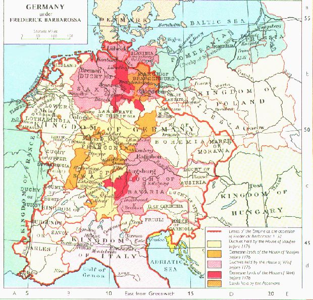
- Germany in the 12th Century -- Available on Culture 4.0 CD-ROM.
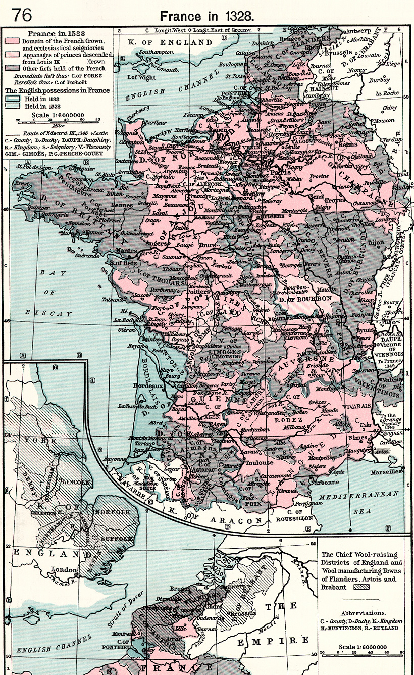
- Growth of the French Monarchy (1100-1337) -- Available on Culture
4.0 CD-ROM.
- South Eastern Europe, 1105 -- Available on Culture 4.0 CD-ROM.
- WWW Maps -- Romanesque & Norman
(1000-1150)
Early Gothic & Ars Antiqua (1150-1300)
- Internal Maps
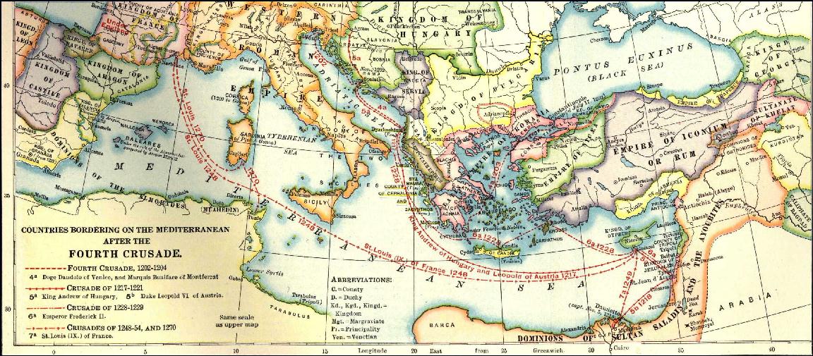
- The 2nd, 3rd and 4th Crusades (1147-1204)
- Germany in the 12th Century -- Available on Culture 4.0 CD-ROM.
- Central Europe, 1180 -- Available on Culture 4.0 CD-ROM.
- English Possessions in France, c.1180 -- Available on Culture 4.0
CD-ROM.
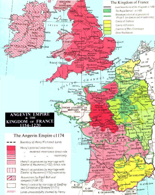
- The Angevain Empire, c.1180 -- Available on Culture 4.0 CD-ROM.
- South Eastern Europe, 1180 -- Available on Culture 4.0 CD-ROM.
- Spanish Kingdoms, 1210 -- Available on Culture 4.0 CD-ROM.
- South Eastern Europe, 1210 -- Available on Culture 4.0 CD-ROM.
- Baltic Lands, 1220 -- Available on Culture 4.0 CD-ROM.
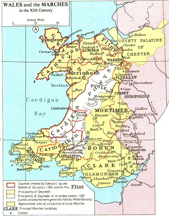
- Wales and the Scottish Borders in the 13th Century -- Available
on Culture 4.0 CD-ROM.
- The Iberian Peninsula from 1257 to 1492 -- Available on Culture
4.0 CD-ROM.
- Baltic Lands, 1270 -- Available on Culture 4.0 CD-ROM.
- Growth of the Habsburg Dominions, 1282-1815
- Growth of the French Monarchy (1100-1337) -- Available on Culture
4.0 CD-ROM.
- Asia under the Mongols, Eastern Sheet -- Available on Culture 4.0
CD-ROM.
- Asia under the Mongols, Western Sheet -- Available on Culture 4.0
CD-ROM.
- Italy in the X, XII, XIII and XV Centuries
- WWW Maps -- Early Gothic & Ars
Antiqua (1150-1300)
Late Gothic & Ars Nova (1300-1400)
- Internal Maps
- France at the Death of Philip IV, 1314 -- Available on Culture 4.0
CD-ROM.
- Growth of the French Monarchy (1100-1337) -- Available on Culture
4.0 CD-ROM.
- South Eastern Europe, 1340 -- Available on Culture 4.0 CD-ROM.
- Baltic Lands, 1350-1360 -- Available on Culture 4.0 CD-ROM.
- South Eastern Europe, 1354-1358 -- Available on Culture 4.0 CD-ROM.
- Europe c.1360
- France, 1360 -- Available on Culture 4.0 CD-ROM.
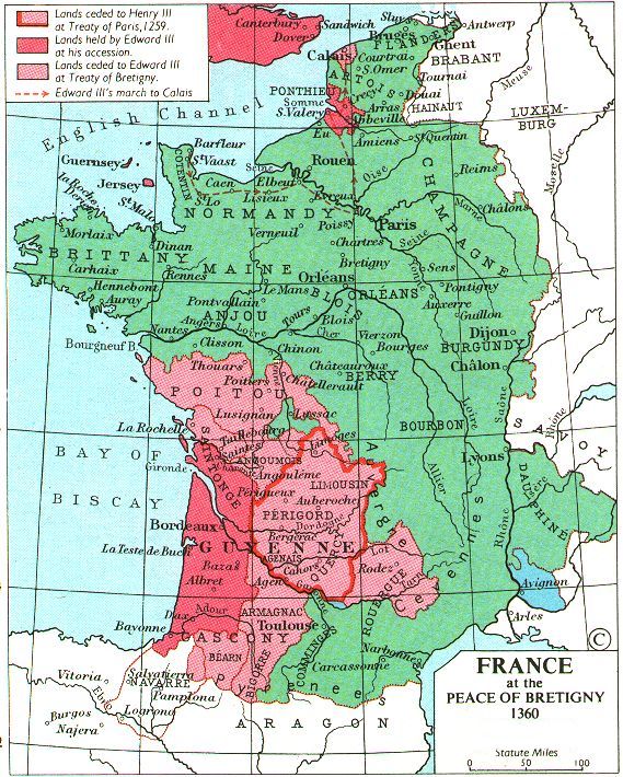
- France at the Peace of Bretigny, 1360 -- Available on Culture 4.0
CD-ROM.
- Spanish Kingdoms, 1360 -- Available on Culture 4.0 CD-ROM.
- Central Europe, 1360 -- Available on Culture 4.0 CD-ROM.
- Baltic Lands, 1400 -- Available on Culture 4.0 CD-ROM.
- Asia under the Mongols, Eastern Sheet -- Available on Culture 4.0
CD-ROM.
- Asia under the Mongols, Western Sheet -- Available on Culture 4.0
CD-ROM.
- The Iberian Peninsula from 1257 to 1492 -- Available on Culture
4.0 CD-ROM.
- Growth of the Ottoman Empire, 1307-1683 -- Available on Culture
4.0 CD-ROM.
- Growth of the Habsburg Dominions, 1282-1815
- WWW Maps -- Late Gothic & Ars Nova
(1300-1400)
Renaissance (1400-1600)
- Internal Maps -- Renaissance (1400-1600)
- Asia under the Mongols, Eastern Sheet -- Available on Culture 4.0
CD-ROM.
- Asia under the Mongols, Western Sheet -- Available on Culture 4.0
CD-ROM.
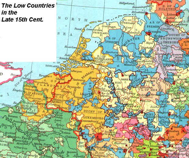
- The Netherlands in the Late Middle Ages and 17th Century -- Available
on Culture 4.0 CD-ROM.
- Baltic Lands, 1400 -- Available on Culture 4.0 CD-ROM.
- South Eastern Europe, 1401 -- Available on Culture 4.0 CD-ROM.
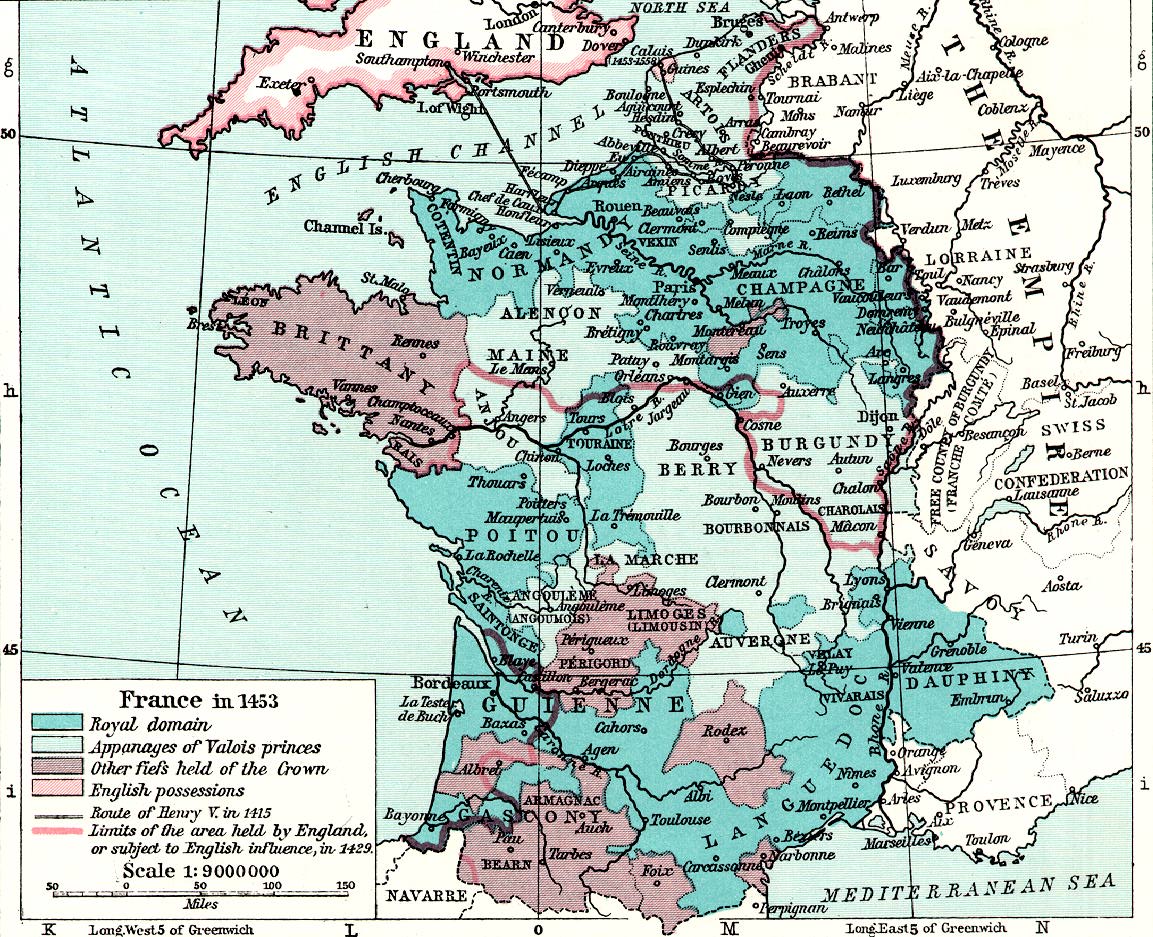
- France at the Death of Henry V, 1422 -- Available on Culture 4.0
CD-ROM.
- France, 1429 -- Available on Culture 4.0 CD-ROM.
- South Eastern Europe, 1444 -- Available on Culture 4.0 CD-ROM.
- Central Europe, 1460 -- Available on Culture 4.0 CD-ROM.
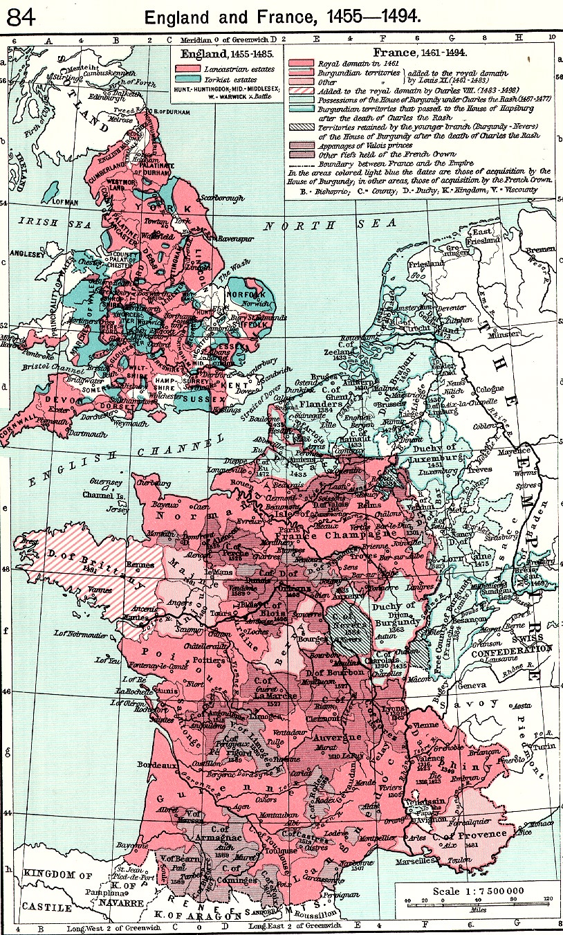
- France, 1461-1595 -- Available on Culture 4.0 CD-ROM.
- South Eastern Europe, 1464 -- Available on Culture 4.0 CD-ROM.
- Baltic Lands, 1478 -- Available on Culture 4.0 CD-ROM.
- The Iberian Peninsula from 1257 to 1492 -- Available on Culture
4.0 CD-ROM.
- Growth of the Russian Empire in Europe 1482-1878
- Italy in the X, XII, XIII and XV Centuries
- Germany at the End of the 15th Century -- Available on Culture 4.0
CD-ROM.
- Europe, 1519 -- Available on Culture 4.0 CD-ROM.
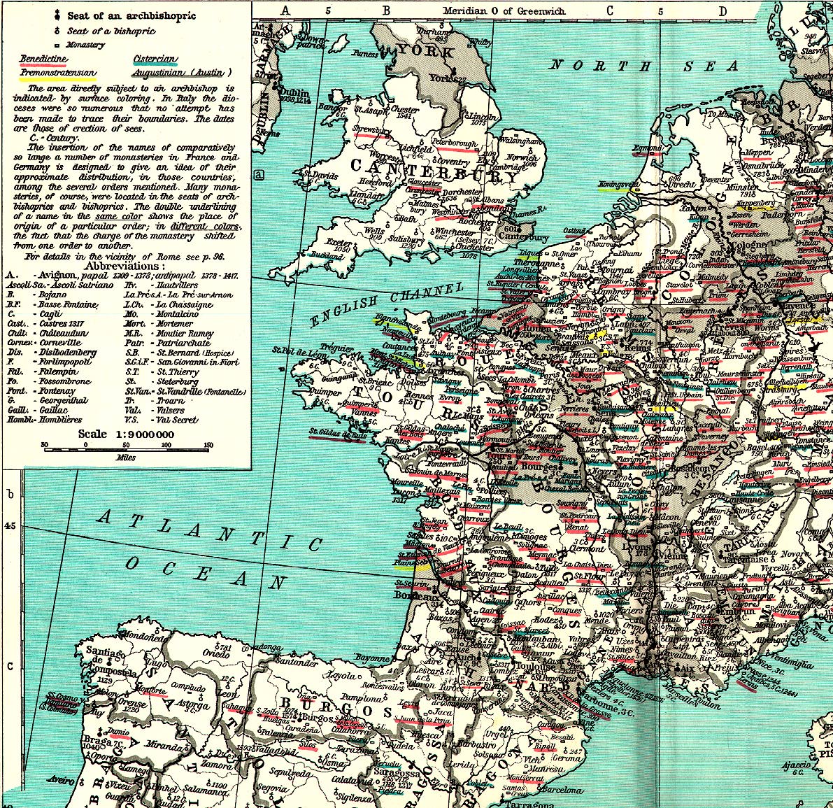
- Eccesiatical England in the Time of Henry VIII -- Available on Culture
4.0 CD-ROM.
- Spanish Kingdoms under Charles V, c.1550 -- Available on Culture
4.0 CD-ROM.
- Central Europe, 1555
- Baltic Lands, 1563 -- Available on Culture 4.0 CD-ROM.
- Reformation Europe -- Available on Culture 4.0 CD-ROM.
- Growth of the Ottoman Empire, 1307-1683 -- Available on Culture
4.0 CD-ROM.
- The Growth of Prussia (1440-1795, 1807-1866)
- Boundary of France, 1555-1871 -- Available on Culture 4.0 CD-ROM.
- Growth of the Habsburg Dominions, 1282-1815
- WWW Maps -- Renaissance (1400-1600)
Baroque (1600-1750)
- Internal Maps -- Baroque (1600-1750)
- British Colonial Grants, 1606-1620 -- Available on Culture 4.0 CD-ROM.
- Baltic Lands, 1617 -- Available on Culture 4.0 CD-ROM.
- England during the Civil War, 1643 -- Available on Culture 4.0 CD-ROM.
- Europe at the Peace of Westphalia, 1648 -- Available on Culture
4.0 CD-ROM.
- The Colonization of America, c.1650 -- Available on Culture 4.0
CD-ROM.
- South America in 1650 and the 19th Century -- Available on Culture
4.0 CD-ROM.
- European Settlements in the West Indies and Central America -- Available
on Culture 4.0 CD-ROM.
- Central Europe, 1660 -- Available on Culture 4.0 CD-ROM.
- Poland, 1667 -- Available on Culture 4.0 CD-ROM.
- Middle Eastern Europe in 1667 -- Available on Culture 4.0 CD-ROM.
- South Eastern Europe, 1672 -- Available on Culture 4.0 CD-ROM.
- British Colonial Grants, 1620-1681 -- Available on Culture 4.0 CD-ROM.
- Growth of the Ottoman Empire, 1307-1683 -- Available on Culture
4.0 CD-ROM.
- Italy in the XVII and XVIII Centuries
- South Eastern Europe, 1700
- Baltic Lands, 1701 -- Available on Culture 4.0 CD-ROM.
- England before (1701) and after (1911) the
Industrial Revolution
- South Eastern Europe, 1727 -- Available on Culture 4.0 CD-ROM.
- Europe, 1740 -- Available on Culture 4.0 CD-ROM.
- Growth of the Russian Empire in Europe 1482-1878
- The Growth of Prussia (1440-1795, 1807-1866)
- Boundary of France, 1555-1871 -- Available on Culture 4.0 CD-ROM.
- Growth of the Habsburg Dominions, 1282-1815
- WWW Maps -- Baroque (1600-1750)
- Historic maps
of Dutch Cartographers (George M. Welling)
- Map
Collection (Amsterdam University Library) -- Text in Dutch.
- London,
c.1630 (NYPL) -- Image and commentary.
- Britannica Maps (see note on Britannica links)
- Austrian
Habsburg Domains from 1525 to 1795
- England during Civil Wars
- Expansion
of the Ottoman Empire, 1300-1699
- Expansion
of Russia, 1300-1796
- Russian Expansion
into Asia, 1533-1894
- French Expansion,
16001766
- Poland, 1031-1945
- Thirty Years'
War, 1618-1648
- English Colonies
in North America, 17th Century
- Spanish Habsburg
Domains in 1648
- Range of
Confessions in Germany, 1650
- The Swedish Empire in 1660
- The English
Plantation of Ireland in the 16th and 17th Centuries
- Irish Land
Ownership by Roman Catholics in 1641, 1688, and 1703
- New France
(Canada), 16th18th Centuries
- 1500-1800
(HyperHistory) -- Interactive world map with contextual links.
- Selections from the Map Collection at University of Texas (Atlas To
Freeman's Historical Geography, 1903).
- European Maps by Christos Nüssli (see his Periodical
Historical Atlas to access individual sections of these larger images)
Classic (1750-1803)
- Internal Maps -- Classic (1750-1803)
- North America, 1750-1783 -- Available on Culture 4.0 CD-ROM.
- French and Indian War, 1756-1762 -- Available on Culture 4.0 CD-ROM.
- India: 1756-1784 and 1805 -- Available on Culture 4.0 CD-ROM.
- Poland, 1772 -- Available on Culture 4.0 CD-ROM.
- Baltic Lands, 1772 -- Available on Culture 4.0 CD-ROM.
- Central Europe, 1780
- United States, 1783 -- Available on Culture 4.0 CD-ROM.
- America during the War of Independence and Civil War -- Available
on Culture 4.0 CD-ROM.
- Slavery in the United States, 1775-1865 -- Available on Culture
4.0 CD-ROM.
- Poland, 1793 -- Available on Culture 4.0 CD-ROM.
- Poland, 1795 -- Available on Culture 4.0 CD-ROM.
- Baltic Lands, 1795 -- Available on Culture 4.0 CD-ROM.
- Middle Eastern Europe in 1795 -- Available on Culture 4.0 CD-ROM.
- Italy in the XVII and XVIII Centuries -- Available on Culture 4.0
CD-ROM.
- Central Europe, 1801 -- Available on Culture 4.0 CD-ROM.
- Growth of the Russian Empire in Europe 1482-1878
- The Growth of Prussia (1440-1795, 1807-1866)
- Boundary of France, 1555-1871 -- Available on Culture 4.0 CD-ROM.
- Growth of the Habsburg Dominions, 1282-1815
- WWW Maps -- Classic (1750-1803)
- John Mitchell's
Map, 1750-1755 (U. of Southern Maine) -- "The Mitchell Map has
been described, and rightly so, as the most important map in North American
history. The most comprehensive map of North America produced during the
Colonial Era, it represented the various territorial claims made by not
only the competing British and French empires but also by the various British
colonies. It has accordingly served, as recently as 1932, in legal disputes
between eastern states. More importantly, it was the map on which the boundaries
of the new United States were defined by American and British negotiators
in Paris in 1782-83; in that capacity, it has continued to be of importance
right up to the 1980s US-Canadian dispute over the Gulf of Maine fisheries."
- United
States of America 1800 (Bodleian Library) -- Anonymous color map.
- Britannica Maps (see note on Britannica links)
- 1500-1800
(HyperHistory) -- Interactive world map with contextual links; see
also the following regional maps at the same site:
-
- Selections from the European
Map Collection at University of Texas (Atlas To Freeman's Historical
Geography, 1903).
Romantic (1803-1912)
- Internal Maps -- Romantic (1803-1912)
- Napoleonic Battles (1805-1815) -- Available on Culture 4.0 CD-ROM.
- India: 1756-1784 and 1805 -- Available on Culture 4.0 CD-ROM.
- The Growth of Prussia (1440-1795, 1807-1866)
- The Iberian Peninsula during the Peninsular War (1808-1814) -- Available
on Culture 4.0 CD-ROM.
- Baltic Lands, 1809 -- Available on Culture 4.0 CD-ROM.
- Europe, 1810 -- Available on Culture 4.0 CD-ROM.
- Central Europe, 1810 -- Available on Culture 4.0 CD-ROM.
- Growth of the Habsburg Dominions, 1282-1815
- Europe, 1815 -- Available on Culture 4.0 CD-ROM.
- Central Europe, 1815 -- Available on Culture 4.0 CD-ROM.
- The German Confederation, 1815-1866 -- Available on Culture 4.0
CD-ROM.
- India in 1858 -- Available on Culture 4.0 CD-ROM.
- Central Europe, 1860 -- Available on Culture 4.0 CD-ROM.
- Slavery in the United States, 1775-1865 -- Available on Culture
4.0 CD-ROM.
- America during the War of Independence and Civil War -- Available
on Culture 4.0 CD-ROM.
- United States during the Civil War, 1861-1865
- Acquisition of Territory by the United States -- Available on Culture
4.0 CD-ROM.
- Development of States in the United States -- Available on Culture
4.0 CD-ROM.
- South America in 1650 and the 19th Century -- Available on Culture
4.0 CD-ROM.
- South Eastern Europe, 1861 -- Available on Culture 4.0 CD-ROM.
- Central Europe, 1871
- Boundary of France, 1555-1871 -- Available on Culture 4.0 CD-ROM.
- Growth of the Russian Empire in Europe 1482-1878
- Europe after the Congress of Berlin (1878) -- Available on Culture
4.0 CD-ROM.
- Italy in the XIX Century -- Available on Culture 4.0 CD-ROM.
- South Eastern Europe, 1881 -- Available on Culture 4.0 CD-ROM.
- England before (1701) and after (1911) the
Industrial Revolution
- WWW Maps -- Romantic (1803-1912)
- University of Texas (The Perry-Castañeda Library Map Collection)
- OSSHE Historical and Cultural Atlas Resource (uoregon)
- Exploring
the West from Monticello: A perspective in maps from Columbus to Lewis
and Clark (U. of Virginia) -- Includes dozens of historical maps and
detailed commentary. Very well done.
- Napoleon's
Empire, 1812 (HyperHistory) -- Interactive map with contextual links.
- Britannica Maps (see note on Britannica links)
- United States,
1783-1812
- United States,
1812-1822
- United States,
1822-54
- United States,
1854-61
- Compromises
over Extension of Slavery into the Territories
- Vote on
Secession in the South by Counties
- United States
after 1861
- Civil War
in the East, 1861-65
- Civil War
in the West, 1862-65
- Sherman's
March to the Sea, November 15December 21, 1864
- Dissolution
of the Ottoman Empire, 1807-1924
- Egyptian Expansion under Muhammad ayn; Ali and Ismaayn il
- Russian Expansion
into Asia, 1533-1894
- Russian Penetration, 19th and 20th Centuries
- Europe, 1812
- France, 1812
- Poland, 1031-1945
- Austrian Empire, 1815-59
- Europe, 1815
- Population
Changes from 1841 to 1851 as a Result of the Great Potato Famine
- The United
Romanian Principalities after 1859
- Unification
of Italy
- Canadian
political development, 18711931
- Europe, 1871-1914
- Growth of
German Zollverein (19th Century)
- German Empire,
1871-1918
- Japanese Expansion in the late 19th and 20th Centuries
- United
States 1823-1845 (Joaquín de Salas Vara de Rey) -- In color.
- Map Index (U.S. Civil
War Center) -- An extensive list.
- Civil War
Map Collection (University of Georgia) -- Several dozen maps are included
in this collection.
- The
Middle East in the Nineteenth Century (upenn) -- From W.C. Brice. An
Historical Atlas of Islam (Leiden, 1981).
- Europe in 1900
(Matthew White) -- Map with links to related maps; nicely done.
20th Century (1912-1999)
- Internal Maps -- 20th Century (1912-1999)
- (forthcoming in Culture 5.0)
- WWW Maps -- 20th Century (1912-1999)
- Historical Atlas
of the 20th Century (Matthew White) -- An interesting collection of
historical maps and commentary providing an overview of the 20th Century.
Well done.
- HyperHistory Interactive Maps
- Britannica Maps (see note on Britannica links)
- Dissolution of the Ottoman Empire, 1807-1924
- Japanese Expansion in the late 19th and 20th Centuries
- German Empire,
1871-1918
- Russian Penetration, 19th and 20th Centuries
- Europe and
the Mediterranean during World War I
- German and
Allied movements on the Western Front, AugustSeptember 1914
- The Eastern
Front, 191417
- Greater Romania after World War I
- Romania after World War II
- Soviet territorial gains after 1922
- Poland, 1031-1945
- Canadian
political development, 18711931
- The Union of Soviet Socialist Republics
- Europe, 1920-1938
- Axis and
Allied movements in Europe and North Africa, 1940-42, and German invasion
of the Low Countries and France, 1940
- The Pacific
Theatre of Operations, 194145
- German and
Allied movements in Europe from the end of 1942 to 1945, and the Normandy
Invasion, JuneJuly 1944
- Europe, 1945-1990
- Israel: United
Nations Partition Plan of 1947
- British India in 1947
- Reorganization of Indian States after Independence (1947+)
- Germany, 1914, 1920-38, 1945-90, 1990
- Germany, 1952-90
- African
Political Systems, 1996
- Maps from Britannica (require unspecified plug-in)
- German and Allied movements on the Western Front, August-September
1914
- The Eastern Front, 1914-17
- Europe and the Mediterranean during World War I
- Soviet
Union 1921-1929 (Joaquín de Salas Vara de Rey) -- In color.
- Map
Machine (National Geographic) -- Access to hundreds of National Geographic
maps.
- Current Political Maps from National Geographic (downloadable with
links to physical and other maps).
- Atlapedia -- Contemporary maps
and related info.
- Map Room (Trenches on
the Web) -- A collection of several dozen WWI maps.
- Treaty
of Versailles (Steve Schoenherr) -- The complete text of the treaty
as well as a nice collection of associated maps.
- World
War II Maps (University of San Diego) -- An excellent archive; also
available arranged chronologically.
- World
War II Maps by Date (University of San Diego)
- World
War II Theaters (Indiana State University) -- Collection and commentary.
- Fascist
Europe 1941-1945 (Joaquín de Salas Vara de Rey) -- In color.
- Maps by Matthew White
- A Virtual Visit to
Vietnam (Vietnam Veterans' Home Page) -- Includes maps.
- World
Political Map, 1998 (utexas) -- (323K)
Grouped Geographically (internal maps only)
- The Americas
- British Colonial Grants, 1606-1620 -- Available on Culture 4.0 CD-ROM.
- The Colonization of America, c.1650 -- Available on Culture 4.0
CD-ROM.
- South America in 1650 and the 19th Century -- Available on Culture
4.0 CD-ROM.
- European Settlements in the West Indies and Central America -- Available
on Culture 4.0 CD-ROM.
- British Colonial Grants, 1620-1681 -- Available on Culture 4.0 CD-ROM.
- North America, 1750-1783 -- Available on Culture 4.0 CD-ROM.
- French and Indian War, 1756-1762 -- Available on Culture 4.0 CD-ROM.
- United States, 1783 -- Available on Culture 4.0 CD-ROM.
- America during the War of Independence and Civil War -- Available
on Culture 4.0 CD-ROM.
- Slavery in the United States, 1775-1865 -- Available on Culture
4.0 CD-ROM.
- America during the War of Independence and Civil War -- Available
on Culture 4.0 CD-ROM.
- United States during the Civil War, 1861-1865
- Acquisition of Territory by the United States -- Available on Culture
4.0 CD-ROM.
- Development of States in the United States -- Available on Culture
4.0 CD-ROM.
- Asia
- The Chaldean, Elamitic and Hittite Powers -- Available on Culture
4.0 CD-ROM.
- The Egyptian, Assyrian, Babylonian and Median Powers -- Available
on Culture 4.0 CD-ROM.
- Probable Route of the Exodus -- Available on Culture 4.0 CD-ROM.
- Canaan as Divided Between the Twelve Tribes -- Available on Culture
4.0 CD-ROM.
- Israel, c.1000 B.C. -- Available on Culture 4.0 CD-ROM.
- Ancient Jerusalem
- Palestine at the Time of Christ
- Asia under the Mongols, Eastern Sheet -- Available on Culture 4.0
CD-ROM.
- Asia under the Mongols, Western Sheet -- Available on Culture 4.0
CD-ROM.
- Growth of the Russian Empire in Europe 1482-1878
- India: 1756-1784 and 1805 -- Available on Culture 4.0 CD-ROM.
- India in 1858 -- Available on Culture 4.0 CD-ROM.
- Baltic Lands
- Baltic Lands, 1000 -- Available on Culture 4.0 CD-ROM.
- Baltic Lands, 1220 -- Available on Culture 4.0 CD-ROM.
- Baltic Lands, 1270 -- Available on Culture 4.0 CD-ROM.
- Baltic Lands, 1350-1360 -- Available on Culture 4.0 CD-ROM.
- Baltic Lands, 1400 -- Available on Culture 4.0 CD-ROM.
- Baltic Lands, 1478 -- Available on Culture 4.0 CD-ROM.
- Baltic Lands, 1563 -- Available on Culture 4.0 CD-ROM.
- Baltic Lands, 1617 -- Available on Culture 4.0 CD-ROM.
- Baltic Lands, 1701 -- Available on Culture 4.0 CD-ROM.
- Baltic Lands, 1772 -- Available on Culture 4.0 CD-ROM.
- Baltic Lands, 1795 -- Available on Culture 4.0 CD-ROM.
- Baltic Lands, 1809 -- Available on Culture 4.0 CD-ROM.
- England and Britain
- Britannia, c.350 -- Available on Culture 4.0 CD-ROM.
- Roman Britain, c.350
- English Conquest from 450 to the End of the Sixth Century -- Available
on Culture 4.0 CD-ROM.
- The English Conquest of Britain, 550-800 -- Available on Culture
4.0 CD-ROM.
- British Isles and their Teutonic Invadors (4th-9th Centuries) -- Available
on Culture 4.0 CD-ROM.
- England in the 8th Century (The Heptarchy) -- Available on Culture
4.0 CD-ROM.
- England in the 8th Century -- Available on Culture 4.0 CD-ROM.
- England at the Treaty of Wedmore, 878 -- Available on Culture 4.0
CD-ROM.
- England and Her Invaders in the 11th Century -- Available on Culture
4.0 CD-ROM.
- England on the Eve of the Norman Conquest, c.1060 -- Available on
Culture 4.0 CD-ROM.
- English Possessions in France, c.1180 -- Available on Culture 4.0
CD-ROM.
- Wales and the Scottish Borders in the 13th Century -- Available
on Culture 4.0 CD-ROM.
- Eccesiatical England in the Time of Henry VIII -- Available on Culture
4.0 CD-ROM.
- British Colonial Grants, 1606-1620 -- Available on Culture 4.0 CD-ROM.
- England during the Civil War, 1643 -- Available on Culture 4.0 CD-ROM.
- British Colonial Grants, 1620-1681 -- Available on Culture 4.0 CD-ROM.
- England before (1701) and after (1911) the
Industrial Revolution
- Europe
- Central Europe
- Central Europe, 843 -- Available on Culture 4.0 CD-ROM.
- Central Europe, 870 -- Available on Culture 4.0 CD-ROM.
- Central Europe, 887 -- Available on Culture 4.0 CD-ROM.
- Central Europe, 980 -- Available on Culture 4.0 CD-ROM.
- Central Europe, 1180 -- Available on Culture 4.0 CD-ROM.
- Central Europe, 1360 -- Available on Culture 4.0 CD-ROM.
- Central Europe, 1460 -- Available on Culture 4.0 CD-ROM.
- Central Europe, 1555
- Central Europe, 1660 -- Available on Culture 4.0 CD-ROM.
- Central Europe, 1780
- Central Europe, 1801 -- Available on Culture 4.0 CD-ROM.
- Central Europe, 1810 -- Available on Culture 4.0 CD-ROM.
- Central Europe, 1815 -- Available on Culture 4.0 CD-ROM.
- Central Europe, 1860 -- Available on Culture 4.0 CD-ROM.
- Central Europe, 1871
- Europe (general)
- Europe, c.476 A.D. -- Available on Culture 4.0 CD-ROM.
- Europe in the Reign of Theodoric, c.500 A.D. -- Available on Culture
4.0 CD-ROM.
- Europe, c.520 A.D. -- Available on Culture 4.0 CD-ROM.
- Europe at the Death of Justinian, 565 A.D. -- Available on Culture
4.0 CD-ROM.
- Europe, c.600 -- Available on Culture 4.0 CD-ROM.
- Europe, c.650
- Europe, 695 -- Available on Culture 4.0 CD-ROM.
- Europe, c.800 -- Available on Culture 4.0 CD-ROM.
- Europe c.1100
- Europe c.1360
- Europe, 1519 -- Available on Culture 4.0 CD-ROM.
- Europe at the Peace of Westphalia, 1648 -- Available on Culture
4.0 CD-ROM.
- Europe, 1740 -- Available on Culture 4.0 CD-ROM.
- Europe, 1810 -- Available on Culture 4.0 CD-ROM.
- Europe, 1815 -- Available on Culture 4.0 CD-ROM.
- Europe after the Congress of Berlin (1878) -- Available on Culture
4.0 CD-ROM.
- Europe (miscellaneous)
- The Netherlands in the Late Middle Ages and 17th Century -- Available
on Culture 4.0 CD-ROM.
- Growth of the Russian Empire in Europe 1482-1878
- Reformation Europe -- Available on Culture 4.0 CD-ROM.
- Poland, 1667 -- Available on Culture 4.0 CD-ROM.
- Middle Eastern Europe in 1667 -- Available on Culture 4.0 CD-ROM.
- Poland, 1772 -- Available on Culture 4.0 CD-ROM.
- Poland, 1793 -- Available on Culture 4.0 CD-ROM.
- Poland, 1795 -- Available on Culture 4.0 CD-ROM.
- Middle Eastern Europe in 1795 -- Available on Culture 4.0 CD-ROM.
- Napoleonic Battles (1805-1815) -- Available on Culture 4.0 CD-ROM.
- Europe after the Congress of Berlin (1878) -- Available on Culture
4.0 CD-ROM.
- South Eastern Europe
- South Eastern Europe, 910 -- Available on Culture 4.0 CD-ROM.
- South Eastern Europe, 1000 -- Available on Culture 4.0 CD-ROM.
- South Eastern Europe, 1040-1070 -- Available on Culture 4.0 CD-ROM.
- South Eastern Europe, 1105 -- Available on Culture 4.0 CD-ROM.
- South Eastern Europe, 1180 -- Available on Culture 4.0 CD-ROM.
- South Eastern Europe, 1210 -- Available on Culture 4.0 CD-ROM.
- South Eastern Europe, 1340 -- Available on Culture 4.0 CD-ROM.
- South Eastern Europe, 1354-1358 -- Available on Culture 4.0 CD-ROM.
- South Eastern Europe, 1401 -- Available on Culture 4.0 CD-ROM.
- South Eastern Europe, 1444 -- Available on Culture 4.0 CD-ROM.
- South Eastern Europe, 1464 -- Available on Culture 4.0 CD-ROM.
- South Eastern Europe, 1672 -- Available on Culture 4.0 CD-ROM.
- South Eastern Europe, 1700
- South Eastern Europe, 1727 -- Available on Culture 4.0 CD-ROM.
- South Eastern Europe, 1861 -- Available on Culture 4.0 CD-ROM.
- South Eastern Europe, 1881 -- Available on Culture 4.0 CD-ROM.
- France
- The Empire of Charlemagne
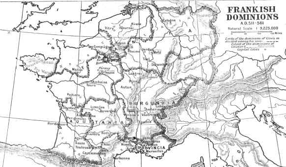
- France and Burgundy, 987 -- Available on Culture 4.0 CD-ROM.
- Growth of the French Monarchy (1100-1337) -- Available on Culture
4.0 CD-ROM.
- English Possessions in France, c.1180 -- Available on Culture 4.0
CD-ROM.
- The Angevain Empire, c.1180 -- Available on Culture 4.0 CD-ROM.
- France at the Death of Philip IV, 1314 -- Available on Culture 4.0
CD-ROM.
- France, 1360 -- Available on Culture 4.0 CD-ROM.
- France at the Peace of Bretigny, 1360 -- Available on Culture 4.0
CD-ROM.
- France at the Death of Henry V, 1422 -- Available on Culture 4.0
CD-ROM.
- France, 1429 -- Available on Culture 4.0 CD-ROM.
- France, 1461-1595 -- Available on Culture 4.0 CD-ROM.
- Boundary of France, 1555-1871 -- Available on Culture 4.0 CD-ROM.
- Germany/Austria
- Greece (shown above)
- Italy
- Roman Empire (see Rome above)
- Aegean Lands c.227 B.C. -- Available on Culture 4.0 CD-ROM.
- Mediterranean Lands at the beginning of the Second Punic War -- Available
on Culture 4.0 CD-ROM.
- Ancient Rome -- Available on Culture 4.0 CD-ROM.
- Roman Dominions, 64 B.C. -- Available on Culture 4.0 CD-ROM.
- The Roman Empire at the Death of Augustus, 13 A.D. -- Available
on Culture 4.0 CD-ROM.
- Roman Empire, c.117 A.D.
- The Roman Empire Divided into Prefectures -- Available on Culture
4.0 CD-ROM.
- Pre-Roman Italy -- Available on Culture 4.0 CD-ROM.
- Ancient Italy -- Available on Culture 4.0 CD-ROM.
- Italy, c.600 -- Available on Culture 4.0 CD-ROM.
- Italy in the X, XII, XIII and XV Centuries
- Italy in the XVII and XVIII Centuries -- Available on Culture 4.0
CD-ROM.
- Italy in the XIX Century -- Available on Culture 4.0 CD-ROM.
- Middle East
- The Chaldean, Elamitic and Hittite Powers -- Available on Culture
4.0 CD-ROM.
- The Egyptian, Assyrian, Babylonian and Median Powers -- Available
on Culture 4.0 CD-ROM.
- Probable Route of the Exodus -- Available on Culture 4.0 CD-ROM.
- Canaan as Divided Between the Twelve Tribes -- Available on Culture
4.0 CD-ROM.
- Israel, c.1000 B.C. -- Available on Culture 4.0 CD-ROM.
- Ancient Jerusalem
- Palestine at the Time of Christ
- Greatest Extent of the Saracen (Muslim) Dominions -- Available on
Culture 4.0 CD-ROM.
- The 2nd, 3rd and 4th Crusades (1147-1204)
- Growth of the Ottoman Empire, 1307-1683 -- Available on Culture
4.0 CD-ROM.
- Spain and the Iberian Peninsula
- Spanish Kingdoms, 1030 -- Available on Culture 4.0 CD-ROM.
- The Iberian Peninsula at the Beginning of the 12th Century -- Available
on Culture 4.0 CD-ROM.
- Spanish Kingdoms, 1210 -- Available on Culture 4.0 CD-ROM.
- The Iberian Peninsula from 1257 to 1492 -- Available on Culture
4.0 CD-ROM.
- Spanish Kingdoms, 1360 -- Available on Culture 4.0 CD-ROM.
- Spanish Kingdoms under Charles V, c.1550 -- Available on Culture
4.0 CD-ROM.
- The Iberian Peninsula during the Peninsular War (1808-1814) -- Available
on Culture 4.0 CD-ROM.
©2000-2010, Cultural Resources, Inc.
